Geodynamics
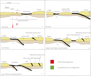
The Iranian mountain belts and plateau range amongst some of the most geologically active regions of the world, whilst offering unrivaled outcropping conditions. This unique combination allows studying short- and long-term deformation processes, magmatic processes and the origin of mineral deposits, as well as large-scale plate tectonic dynamics. Having remained on the edge of the Eurasian upper plate during much of the subduction- then collision-related Meso/Cenozoic history, Central Iran provides a continuous geological record of convergence and closure of the Neotethyan realm. The multidisciplinary approach pursued here (from the field to models) will tackle such processes as: (i) deformation partitionning within the upper plate from the Neogene to present, and the role of tectonic inheritance (in the Zagros, Alborz and Sistan, but also for the whole of Iran), (ii) long-term mechanical coupling associated with subduction, (iii) the nature and emplacement mechanisms of the many ophiolites criss-crossing the country, and (iv) magmatic evolution, particularly over the last 50 My which represent a prominent contribution to the mineral resources of Iran. Complementary studies on the region to the SW of the Main Zagros Thrust (e.g., Lorestan, Fars), formerly part of Arabia, will provide insights into basin formation, tectono-sedimentary processes, and fluid migration.
Mineral Resources
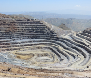
In addition to oil and gas reserves, Iran hosts a wealth of metal resources (eg, being the first and second country in the world for zinc and copper reserves, respectively), a large part of which is tightly linked to Tertiary magmatism in Central Iran and adjacent belts, or to ophiolites. Chromium, platinum group metals, rare earth elements (but also iron or gold) abound across the country. The goal of this sub-theme will be to refine or establish the petrological and tectonic model for ore genesis, with implications for future mining operations and economic development.
Seismic Hazard
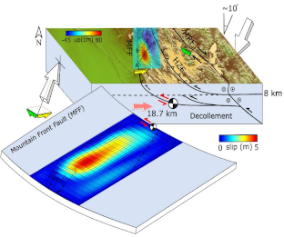
Iran is one of the most seismically active intracontinental domains in the world, with earthquakes nesting in mountain belts (Talesh, Alborz, Kopeh Dagh, Zagros) as well as along the numerous major strike-slip faults that cut across the country. The vulnerability of major citites such as Tehran, located on the southern slope of the Alborz (e.g., Rudbar earthquake in 1990, ~250 km to the NW of Tehran; Mw 7.3, ~ 40,000 casualties), and other large cities (Tabriz, Mashad, Ispahan,…) is a big threat and a major challenge for risk assessment. This part of the project will combine space geodesy, seismic instrumentation and paleoseismology, using both permanent instrumental arrays in Iran and temporary arrays to construct a very large database with dense (instrumental and paleosismological) time series. This database will be used in local and regional studies devoted to estimating seismic and gravitational hazard in a probabilistic way.